Joining the Brussels Ring Road in the south would not help traffic
Joining the Brussels Ring Road in the south would not help traffic
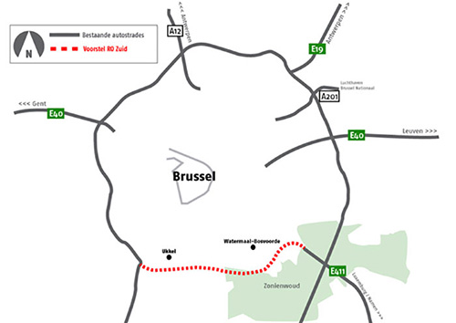
If you look at the Brussels Ring Road, you can see that it has an atypical shape. The Ring Road under Brussels was not made round between Drogenbos and Tervuren but goes further south and connects in Ittre. This means that, for certain journeys, people have to make a big detour. For instance, if you want to drive from Beersel towards Leuven, you have to drive more kilometres via the Brussels Ring Road than the distance as the crow flies. Some people believe that joining the Ring Road just south of Brussels would mean less traffic on the northern side of the Ring Road. However, studies show that this would not be the case.
Where would the southern ring road go?
The southern connection of the Ring Road that was researched would begin between junction 17 (Vorst) and 18 (Drogenbos) in the west and would join the E411 at the Waversesteenweg in the east. From there, people would drive on the Ring Road once again. With this solution, the Sonian Forest (Zoniënwoud) would be spared as much as possible.
No significant traffic reduction
In the study, a certain reduction in the volume of traffic was set as a target. For every option, research was done into the extent to which the solution met the target. For a southern joining of the Brussels Ring Road the figure amounted to no more than 7%. By comparison, the option with express/local lanes reached 70% in some parts. The joining of the Ring Road in the south did not meet the target and so was not further investigated in the Strategic Environmental Impact Report (Strategisch Milieueffectenrapport, S-MER) and the Social Cost-Benefit Analysis (Maatschappelijke Kosten-Batenanalyse, MBKA).